
Highland County is fortunate to serve as home to state park lakes. And there might have been a third if a proposed lake project from the late 1950s in the southern part of the county had come to fruition.
According to the Ohio Department of Natural Resources, Rocky Fork Lake was added to the Ohio State Parks system in 1950 and is 1,992 acres in size with nearly 31 miles of shoreline.
Paint Creek Lake, which reached pool level in 1974, is 1,190 acres and has more than 30 miles of shoreline, according to the ODNR.
A news article that appeared in the former Cincinnati Post & Times-Star dated June 10, 1961 described plans for a proposed new state park called Whiteoak Lake, with the Ohio General Assembly voting an appropriation to study its viability in 1959.
The newspaper story said that Brown County organizations, led by the Mount Orab Chamber of Commerce, had been pushing hard for the creation of Whiteoak Lake despite a recent decision by the Ohio Natural Resources Commission not to consider construction at the present (1961) time.
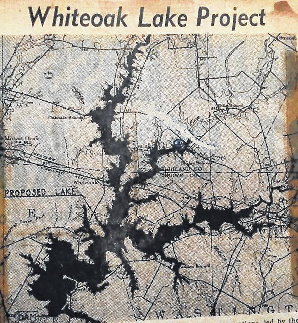
Whiteoak Lake, according to a preliminary engineering survey completed in late 1960 by the ODNR, would have covered more than 1,700 acres of land with nearly 75 miles of shoreline, stretching northeast from north of New Hope in central Brown County to just south of Buford in the extreme southwestern corner of Highland County in Clay Township, with another fork snaking eastward in the direction of Flat Run Creek near SR 134.
Another fork of Whiteoak Lake, according to the survey, would have extended into northeastern Brown County before terminating in the Sardinia area.
The engineering survey proposed a dam would be built near the intersection of Bingamon Road and U.S. Route 68 between Georgetown and Mount Orab, with the largest part of the lake basin flooding an area bordered by Brannon and New Hope-Whiteoak Station roads on the west and east, and Oakland Road to the north.
Whiteoak Lake’s next largest basin was just west of Sardinia, bordered on the north by SR 74 and Wardlow Road, with the southern border being Stephan Road.
Ohio Department of Transportation records state that in 1962, SR 74 was renamed SR 32, and after completion of the Appalachian Highway in 1981, had another name change to Tri-County Highway.
The estimated cost to build Whiteoak Lake, which the ODNR study said would have joined the state parks system in 1968, was more than $3 million, which accounting for inflation would be equal to more than $26 million today, according to the inflation-calculating website dollartimes.com.
Three freshwater lakes within a short drive of Hillsboro joined the state park system in Ohio after Whiteoak Lake was abandoned nearly 58 years ago; Cowan Lake State Park south of Wilmington opened in 1968, the same year that Whiteoak Lake was slated to open; Paint Creek State Park began in 1974 and Caesar Creek State Park at Harveysburg was established in 1978. Pike Lake State Park in Pike County was established in in 1949.
Reach Tim Colliver at 937-402-2571.

