
According to the National Weather Service in Wilmington, severe weather in the form of “super cell thunderstorms” Monday night spawned a line of tornadoes that tore a path of destruction from eastern Indiana through the Greater Dayton area, leaving an elderly Celina man as the only confirmed death caused by the storms.
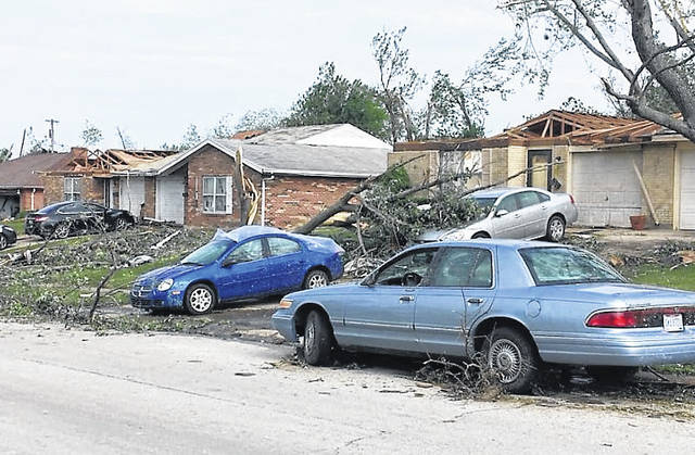
In Ohio, the storms wreaked havoc in Mercer, Montgomery, Greene and Pickaway counties, with the weather service confirming Tuesday that E3 tornadoes with winds up to 140 mph hit Trotwood and Beavercreek.
A spokesman for Dayton Power & Light Company said that more than 60,000 of its customers were without power Tuesday and that the utility considered requesting mutual aid from neighboring utilities such as AEP and South Central Power to get the lights back on.
AEP Ohio Public Information Officer Jessica Wright told The Times-Gazette that though her company is able and ready to give assistance, they haven’t received such a request from the Miami Valley utility.
Mark Owen, communications manager for South Central Power, said that they are wrestling with what he called “pretty significant damage” in Pickaway County with about 4,200 without power in the Circleville and surrounding areas.
“It’s not that big a number in the grand scheme of things,” he said. “We’re doing damage assessment and finding a large number of broken utility poles and damaged transmission lines, so it’s going to take a while for us to get rebuilt ourselves.”
He said the utility had repair crews deployed and that they faced reinstalling utility poles and engaging in clean-up efforts with emergency responders in several towns due to the large number of downed trees.
“This may be a longer event than what we face when restoring power after a typical thunderstorm,” he said. “I had heard reports that DP&L is projecting their repairs may take three to five days, but in light of our own damage assessments, hopefully, it won’t take us that long to get things back up.”
Weather forecasters at WKEF-TV in Dayton said in a televised report the tornado that traced a destructive path north of the city was on the ground for almost 40 minutes with a ground track of 20 miles, which Ashley Novak of the NWS office in Wilmington said is typical of how super cell thunderstorms behave.
She said storms of that magnitude produce higher wind velocities and tend to cause tremendous amounts of damage due to the amount of “spin up” that may develop within it, even if they don’t produce actual tornadic activity.
“These storms initiated further west with quite a few bad storms in Illinois and Indiana earlier in the day,” she said. “As the day progressed and temperatures started to rise, they moved into the south central Ohio and Miami Valley region.”
She said weather service meteorologists like herself saw more than the typical “hook echo” on their radar and computer screens, and began seeing what she described as a “tornado debris signature,” which is airborne debris generated in the path of a twister.
The NWS dispatched personnel to gather data on the Monday evening storms, such as its path and intensity, she said, with most of their efforts centered in the Trotwood, Beavercreek, Celina and Circleville areas.
Reach Tim Colliver at 937-402-2571.

