
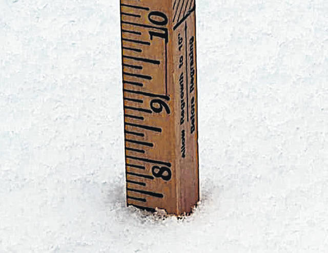
Highland County received one of its more heavy snowfalls in recent years overnight Monday and into Tuesday morning. According to the National Weather Service in Wilmington, the county received anywhere from 6 to 9 inches, including 7.5 inches in the Hillsboro area.
“We had a pretty fast-moving, low-pressure system that moved through the Tennessee Valley,” said Allen Randall, a meteorologist at the Wilmington NWS station. “We were on the northern periphery of that storm. A band of, I’ll call it, enhanced band of snow developed late last evening into the overnight hours where some of the highest totals … and Highland County was in that band and from what we’ve got, we’ve got like 6 to 9 inches across the county there, pretty widespread.”
Randall said the NWS did not have records indicating the last time was that Highland County received that much snow from a single weather event.
While the NWS did not have past numbers for Hillsboro or Highland County, Randall said that in terms of snowfall inches in Cincinnati, “the normal value up through last night was 13.5, up to that date, ending at midnight, and with this snow, at that point, it had 5.7 for this event, with that snow they were at 14.3. So, they were only .8 above normal.”
Hillsboro Police Department Sergeant Aaron Reynolds said that while there was only one actual accident — a private property incident where a car slid and hit a pole on private property — the roads were slick and made traffic slow. Reynolds also said some cars got stuck and needed help getting out.
Highland County Sheriff Donnie Barrera said that even though the area was slick and some cars slid off the road, things were well-run by the county considering the amount of snow it received.
“We issued a Level 1 yesterday and then we went up to a Level 2 this morning, and we’re now back down to a Level 1,” Barrera said. “They got the roads pretty cleared to state, county and the crews have been out all evening, and they’ve done an excellent job of getting our roads in shape.”
More wintry weather is heading this way. Randall said a new storm will begin Wednesday night and going into Thursday, ending that night. He said that storm looks to be bringing another possible 2 to 4 inches to the area.
“It does look we’ll have a little more confidence as we go into the weekend that temperatures do turn colder,” Randall said. “So, a shot at some lighter snow, maybe, and then as temperatures turn colder, we get into the weekend. Highs in the mid-teens Sunday and Monday, and with lows in the single-digits late this weekend into early next week.”
Randall said that the next week or so is going to feel like winter. The area will be colder than normal and when it gets storm systems, the area will have a chance of snow.
“We’ll have to see how this pans out because we are gonna be colder than normal for the next week plus, and when these storm systems do affect our region we’ll be adding to our snow total,” he said.
Reach Jacob Clary at 937-402-2570.

