
Mother Nature and Old Man Winter teamed up to deliver double blows to Highland County Monday and into early Tuesday, with two rounds of bad weather that had the potential of leaving up to a foot of snow on the ground in areas to the north, and lesser amounts of snow mixed with ice and freezing rain for Hillsboro and the vicinity.
The National Weather Service in Wilmington reported that round one moved through the area Monday starting at around 4:30 a.m., dumping anywhere from two to four inches of snow before moving off three hours later.
Staff meteorologist Matthew Campbell of the National Weather Service told The Times-Gazette that the forecast model for Highland County had been revised Monday morning to include more freezing rain and sleet mixing in for an expected second round Monday afternoon.
“We’re forecasting another batch of snow coming into Highland County, and then mixing in with sleet and some freezing rain,” he said. “That will continue throughout the evening, creating some slick travel conditions, before it moves out in the overnight ending as just snow.”
Interstate 71 seemed to be the boundary line between areas that would receive significant amounts of snow, Campbell said, with areas to the north of it expected to get nearly a foot, and areas to the south experiencing somewhat lesser totals with a sleet/freezing rain mix.
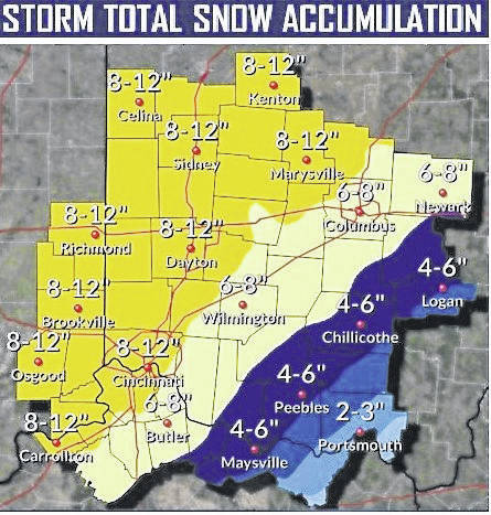
An updated map Monday afternoon from the National Weather Service showed a boundary line with moderate snowfall extending from southwest to the northern part of Highland County, with lesser amonts forecast for the southeastern part of the county.
The map revision showed that areas north of that line could expect three to four inches of snow, with another line at Wilmington forecasting four to six inches.
The southeastern part of Highland County was predicted to receive an additional inch or two of snow, plus the chance of freezing rain or drizzle.
“That seven to 12 inches of snow we’ve been talking about is more than likely northwest of Dayton, up there it should stay all snow,” he said.
Regardless of what falls from the sky, Matt McGuire of the Ohio Department of Transportation’s District 9 headquarters in Chillicothe said snow plows were on the road and ready to engage the battle.
“We’ll be prepared no matter what,” he said, “but the main thing we like to remind the public is that during the actual storm, our goal is to keep things passable, not perfect, you’re not going to see clear pavement in the middle of a snowstorm.”
He said that after the storm passed was when ODOT crews will begin regaining ground and returning roadways to being clear and safe, and advised motorists to exercise extreme caution when encountering snow plows.
“We always say ‘don’t crowd the plow,’ and when you see us out working, the best thing you can do is give us as much space as possible,” he said. “The less traffic that is around us makes it easier for us to do what we do, and get the roads opened up quicker.”
Campbell indicated the winter storm will be following a west to east ground track, and McGuire said that due to that, whatever comes to Highland and Brown counties will prepare crews for what to expect in Ross, Pike and Jackson counties.
“The counties down along the river — Adams, Scioto and Lawrence County — are supposed to get ice and freezing rain,” McGuire said. “So if we get that along with snow, that’s going to be a whole other kettle of fish.”
ODOT’s District 9 is responsible for maintaining highway integrity in Highland, Adams, Brown, Ross, Pike, Jackson, Lawrence and Scioto counties in southern Ohio, including the greater Chillicothe region.
The National Weather Service is forecasting more snow Wednesday night, Thursday during the day and overnight, and Sunday night into Monday.
Reach Tim Colliver at 937-402-2571.

