
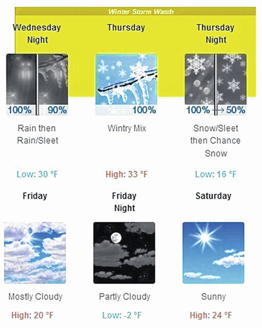
A looming storm beginning with rain during the day on Wednesday is threatening to turn into a mix of sleet and freezing rain causing dangerous road conditions in Highland County by Thursday morning, according to the National Weather Service in Wilmington.
Accumulating ice and gusty winds that have the potential to cause possible problems with trees and downed powerlines are predicted during the day on Thursday.
“At first, precipitation will begin as rain, and the rain could be heavy at times, so there might be some minor localized flood issues,” said Julie Reed, a meteorologist with the National Weather Service in Wilmington. “Then there will be a transition over to what we’re looking at as the primary threat for the Highland County, Hillsboro area that would come in Thursday morning in the form of freezing rain.”
Reed said there could be a mix of sleet and freezing rain and the potential for a prolonged period of freezing rain.
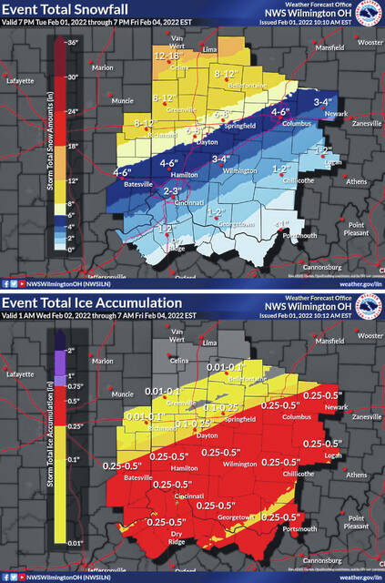
The forecast from the National Weather Service in Wilmington is predicting up to a quarter inch of ice in the area.
“You’re also going to be starting to get some gusty winds during the day on Thursday, so the problem there is if you get the combination of accumulating ice with wind gusts up to 25 miles an hour or greater that will further exacerbate the potential for tree and power line issues,” said Reed.
A transition to snow is predicted to follow the freezing rain and sleet. “I don’t think that’s going to be happening in terms of the changeover to snow until Thursday night,” said Reed. “The total snow that we’re expecting right now is on the order of about 2 to 3 inches, but the forecast is being updated at this time, so this could change.”
Reed said the main threat of the storm, especially Thursday, stems from the mixed precipitation combined with wind that will change over to snow by Thursday night. “The winds will start to diminish, but the big thing is travel is going to be pretty treacherous, and there could be issues with power,” she said.
She attributed the potential storm to a potent weather system with a great amount of cold air behind it.
Reed recommended having a plan to deal with the weather. “Ideally, it’s best not to travel on Thursday to Thursday night, but if you must, make sure you have some snacks, blankets, water, and extra layers of clothing in your vehicle,” she said.
She also said having plenty of food and water at home along with battery operated flashlights and other lighting sources is a good idea. “Just be prepared in case there is any disruption to power,” she said.
Reach John Hackley at 937-402-2571.


